Figure 1. The Map of 'Orbis Terrarum' by Abraham Ortelius shows a world vision during the great discoveries. (Ortelius, 1570)
I Introduction
Geography, as an interdisciplinary specialisation incorporating the sciences and the humanities, is an indispensable tool for comprehending and interpreting the multifaceted relationships between living beings and the space in which they live (Cresswell, 2013). Regardless, we must remember that its development is permanently linked to the historical processes forming our world (Livingstone, 1992; Godlewska et al., 1994). This essay aims to investigate and research the impact of the European expansion of the XV century on the theory and practice of geography in the modern world (Pagden, 1995; Seed, 1995).
Since the Age of Discovery, geography as a scientific discipline has passed distinct stages, shaped by historical expansion, colonisation, decolonisation, and globalisation (Blaut, 1993: 23). These critical moments in history help us understand how the role and perception of geography have changed (Cosgrove, 2008; Cresswell, 2013) and how this science has contributed to shaping our collective consciousness (Barnett, 1995). During the Age of Geographical Discoveries, this discipline became a colonial expansion tool, supporting exploration and domination over newly discovered territories (Seed, 1995: 17-18). Geography undeniably played a crucial role in shaping Europeans' perceptions of the world and influenced their expansion strategies and colonisation choices (Pagden, 1995: 38-39). We will analyse how the processes of colonisation influenced the development of geography as a scientific discipline, showing that geography was not a neutral tool of cognition but an integral part of the imperial power structures that reinforced and consolidated colonial supremacy (Blaut, 1993; Godlewska et al., 1994).
At this stage, we will draw on the scholarly output of authors such as Tim Cresswell, whose work "Geographical Thought: A Critical Introduction" (2013) provides an invaluable analysis of geography
in the context of epistemology and critical reflection on geographical thinking. Cresswell shows how geography was used to justify and guide European expansion and how geographical constructions influenced colonial practices.
Further into our analysis, we will focus on the impact of decolonisation on geography. We will consider how this global process has affected geographical studies and our thinking about space and place. We will discuss the work of J.M. Blaut, notably his "The Colonizer's Model of the World: Geographical Diffusionism and Eurocentric History" (1993), where he posits that the Eurocentric model of geography, which assumed that Europe was a 'centre of civilisation' that spread to other regions, was not only wrong but also harmful. We will analyse how this model legitimised imperialism and colonisation, helping Europeans to rationalise expansion as a civilising process.
However, we must remember that geography is not a static discipline. History proves the discipline can adapt to changing conditions and contexts (Barnett, 1995: 417). In the post-colonial era and globalisation, geography has adapted to new realities by changing its approach and perspective (Cresswell, 2013: 139). It has moved from discovering and classifying space to analysing the social, political, and cultural processes that shape our surroundings (Cosgrove, 2008: 63; Harley, 1989). We will consider how our understanding of space and place has changed in response to these processes and what new challenges and opportunities geography faces in the age of globalisation (Cresswell, 2013).
In conclusion, this essay aims to comprehend how geography as a scientific discipline has developed and how these transformations affect how we understand and interpret the world around us. It aims to examine the impact of historical processes on the development of geography and formulate questions about the discipline's future in an era of global variability, which is a scientific and ethical challenge. Given geography's colonial legacy, we wonder what the ethical implications of our thinking about geography are. Can we detach geography from its colonial past? Should we, and if so, how? Furthermore, most importantly, do our current geographic practices help to create a more just and sustainable world, or do they maintain inequalities and divisions? These questions are central to our understanding of geography and shaping the future of this discipline and the world we live in.
II Geography in the Age of Exploration
During the Age of Geographical Discovery, the role of geography as a science undoubtedly became crucial. New territories discovered by European voyagers provided new areas to explore and created space for the expansion of new geographical ideas that ultimately revolutionised Europeans' knowledge of the world (Cosgrove, 2008; Ogborn, 2008). However, it must not be forgotten that what the Europeans' discovered' was not new to the native peoples of these areas (Blaut, 1993). Still, these discoveries expanded the geographical knowledge base, letting scientists establish new geographic theories and concepts (Cresswell, 2013: 28-32; Barnett, 1995: 417-418).
Behind this expansion of science were the vital geographical theories of the Age of Discovery. One of these was the theory of climatic spheres, suggesting that climate varies with latitude. However, this theory was not new - its roots can be traced back to ancient Greece and the work of Hippocrates, who outlined the basic principles of bioclimatology in his treatise 'On Air, Waters and Places' over 2,000 years ago (Brittanica, 1998). The growing understanding and mapping of newly discovered territories was vital during the Age of Discovery (figure 1). These theories influenced not only the understanding of the world but also decisions about expansion and colonisation. For example, the theory of climatic
spheres were used to justify colonisation, claiming that certain 'spheres' were less hospitable to human life and therefore needed to be 'civilised' by Europeans (Blaut, 1993, pp. 70-71).
Thus, regarding these discoveries, geography was not just a science but also a tool. Europeans used geographic practices such as mapping, measuring, and describing territories to shape and understand new areas (Cosgrove, 2008: 87-88). This instrumentalisation of geography for colonisation and expansion shows how science was applied to shape and manage colonies (Cresswell, 2013: 37).
Hence, geography in the Age of Discovery became a field for developing theories and a pragmatic tool to shape the politics of the time (Livingstone, 1992). The impact of mapping and describing new territories was profound (Harley, 1989). Alongside this, the creation of theories explaining their climate, terrain, and the distribution of continents influenced decisions regarding expansion and colonisation (Blaut, 1993). In turn, this led to the development of new geographical practices, which became increasingly advanced in line with the development of colonial expansion (Godlewska et al., 1994).
However, this dynamic development of geography was not without ethical controversy. Geography became a tool of power and colonisation. European geographers often failed to consider the consequences of their actions for the indigenous peoples of the newly discovered territories, which led to questioning the moral responsibility of scientists for the effects of colonialism, which were often the result of their research and theories (Bhambra et al., 2018).
In the context of the complex interaction between discovering and colonising brought about by European expansion, Clive Barnett's argument in "Awakening the dead: who needs the history of geography?" takes on a particular force (Barnett, 1995). Barnett stresses that reflection on our scientific heritage should not be limited to simply bringing old theories back to life but should confront how they were formed and influenced practices in their time (Barnett, 1995). In the age of the great geographical discoveries, it cannot be ignored that the development of geographical theories was strongly linked to European expansion and colonialism. The climatic sphere, the theory of continents and even the mapping processes were part of the discourse to justify and reinforce European domination over 'newly discovered' territories (Barnett, 1995). As Barnett suggests, a focus on contemporary disciplinary understandings and practices could help to critically assess the impact of our geographical past on current relations between knowledge and power (Barnett, 1995: 417-418).
To summarise, geography in the Age of Discovery was a science and a tool of colonial expansion. The new geographical theories and concepts that emerged from geographical discoveries influenced colonisation decisions, and geographers themselves played a crucial role in shaping and understanding the newly discovered territories and providing direction for further expansion. This instrumentalisation of geography points to its complex and controversial role in the history of European expansion.
III. The impact of colonisation on the development of geographical thought
The era of geographical discoveries, considered a critical turning point in human history, undoubtedly influenced the development of geographical science. The discovery of the New World by European explorers was fundamental to the progress of geography. Geography began to play a strategic role in European expansion, providing the necessary tools to understand and control newly discovered lands (Harley, 1988).
The first and most obvious impact of the colonisation process on the development of geography was the growing importance of cartography. Accurate maps became an indispensable tool for expansive settlers, enabling effective colonial management and navigation. Geographers and cartographers, who were members of exploration teams, worked to create detailed maps of new territories, enabling
colonisers to plan their next expansion steps accurately. Light is shed on this issue by the Ribero map (figure 2), which shows how, thanks to precise maps, colonisers were able to negotiate and push the boundaries of their influence, as was the case in the Treaty of Zaragoza in 1529 when Portugal paid Spain 350,000 ducats to move a line in the Pacific further east and protect its monopoly on the Spice Islands (Turnbull, 1996).
Consequently, geography began as a new discipline incorporating new research methods, tools, and techniques. Technological advances, such as the refinement of the telescope or compass, supported this development and advances in the natural sciences, which became vital components of geography. Such advances have opened new perspectives for researchers, enabling them to understand and study the Earth better. An example is the story of the Yalata Aboriginal map, which was used to support land claims before white courts (Turnbull, 1996). This history shows how maps, traditionally used for expansion and colonisation, can also be mobilised and used to defend indigenous peoples' land rights, an exciting development in the context of the impact of colonisation on the practice of geography.
Furthermore, the process of colonisation led scholars to portray the discovered territories as 'savage', 'uncivilised' or 'empty'; it provided a justification for conquest and colonisation, legitimising the dominance of Europeans (Seed, 1995: 28). Paradoxically, geographical practices such as mapping were presented as evidence of the 'improvement' of these territories (Seed, 1995: 24).
Nonetheless, the lasting impact of colonisation on modern geography cannot be overstated. The tools and methods developed during the Age of Great Discovery underpin contemporary geographical practice. In the post-colonial era, scholars have begun to question these practices, drawing attention to the need to analyse the colonial legacy of geography (Harley, 1988: 292).
Finally, the colonisation process contributed to the development of geography and forced the academic discipline to reflect on its heritage. Geography has had to confront the problematic legacy of colonialism by asking about its place in this process and considering its potential consequences for the reproduction of inequality and domination (Harley, 1988: 303).
The relationship between colonisation and geography is complex and multidimensional. What began as European expansion transformed geography into a science full of tools, methods and techniques that
helped to understand and control newly discovered territories. However, this transformation has been controversial and complicated the legacy of geography that we must reflect on and understand today.
IV. Critical reflection on the impact of colonialism on geography
From postmodernism to postcolonialism, one significant aspect of the influence of colonisation on geography that deserves further analysis is its complex interconnection with the ideologies and discourses that dominated the era, highlighted in F. Driver's work 'Geography's empire: histories of geographical knowledge', in which the author recalls the reflections of thinkers such as Said and Habermas (Driver, 1992).
The former, Edward Said, emphasised in his work the danger of ideological assumptions about the 'end of history' (Driver, 1992: 37). Considering the colonial impact on geography, this implies an understanding that abandoning one paradigm (e.g., European domination) does not mean erasing other possibilities from history and geography. It suggests that despite the triumph of the West during the colonial period, many other possibilities for development are still open, which can lead to emancipatory politics, as Said points out (Driver, 1992: 30). Writing about postmodernism, Driver (1992) suggests that, despite his critique of 'master narratives' (including Orientalism), it is incomplete. Habermas (Driver, 1992: 32) sees modernism as an 'unfinished project', expressing a longing for continued dialogue and discussion. Similarly, colonial geography, with its emphasis on cartography and the development of tools to control 'discovered' territories (Harley, 1988: 281), must be continually questioned and its histories and possibilities reconsidered.
In conclusion, while European expansion and colonisation were central to developing geography as a scientific discipline (Turnbull, 1996), continuing the dialogue and critical analysis of these processes is essential, highlighting the need to reflect on how the history of geography is interpreted and presented. Adopting a post-colonial perspective can lead to new understandings and possibilities for this science, far removed from the European dominance paradigm that has existed for so long in its history (Said, 1978; Driver, 1992).
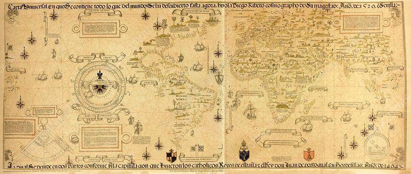
Figure 2. Map of the World by Diego Ribero (1529) depicts Pope Alexander VI's demarcation line, dividing the undiscovered world between Spain and Portugal. The demarcation of this line, although the lack of precise tools and techniques to locate or define it, had enormous political consequences. The map enabled the world's division, which was crucial to European expansion plans (Turnbull, 1993).
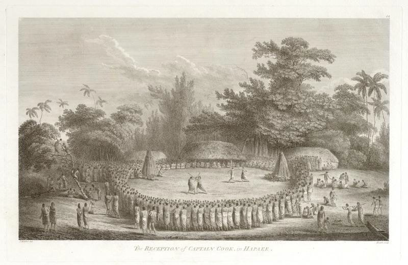
Figure 3: "The Reception of Captain Cook, in Hapaee" by John Webber and James Heath, 1784. (Webber et al., 1784).
V. Ethics and morality in colonial geography: a summary
Colonial geography strongly suggests a complex interplay between knowledge, power, and space. In the colonial era, geography was often used to construct narratives legitimising colonial processes. What Europeans considered 'wild' and 'uncivilised' territories were often portrayed as areas in need of 'enlightenment', which served as a pretext for plundering resources and exploiting people and space. The painting 'The Reception of Captain Cook, in Hapaee' by John Webber in 1784 (figure 3) is an excellent example of how these 'wild' territories were perceived (Webber et al., 1784). Webber accompanied James Cook, the famous British traveller, on his voyage to the Tonga Islands in Polynesia. The scene shows Cook and his crew on the beach, watching the locals engage in physical competitions: boxing and stick fighting. This image, like many others from the period, helped to create an image of the 'savage' and 'uncivilised' inhabitants of the colonised territories, which helped to legitimise colonial processes. Tim Cresswell argues that geography was crucial in maintaining colonial power, being used to map, measure, and categorise newly discovered territories (Cresswell, 2013). This perspective
provides an understanding of how geography was used as a tool of colonialism to help maintain and negotiate power structures.
The question of geographers' responsibility in colonial processes is vital in this context. Were they merely tools in the hands of the colonisers, or were they active contributors to colonial processes? As Driver notes, many geographers were actively involved in colonial processes, contributing to maintaining and promoting European domination (Driver, 1992). Sometimes, even unwittingly, they became complicit in colonial injustices. This troubled past has had an enormous impact on contemporary geography.
Consequently, geography must confront this history and re-evaluate its roles in colonial processes. In a post-colonial context, a critical view of colonial geography is essential despite its positive aspects, such as the development of the natural sciences. Derek Gregory notes that colonial geography was an integral part of more comprehensive processes of exploitation and domination that deserve deep critical examination (Gregory et al., 2007). His work points to the need to understand these processes and confront the colonial legacy of geography.
Patricia Noxolo further explores the concept of decolonising geography, which means critically examining and re-evaluating traditional Eurocentric approaches to geography. Introducing often overlooked perspectives, such as those of indigenous peoples, colonised communities, or gender perspectives, is crucial to creating a more sustainable and inclusive geography (Noxolo, 2017). This new decolonised geography could build a more equitable and understanding world vision.
Understanding how geography has been used to sustain and maintain power structures can lead to reflection on its current uses. Geography is still used to create and maintain power structures, although not necessarily in the context of colonialism (Noxolo, 2017). However, understanding this past is critical to comprehending what more equitable and sustainable geographical practices might look like.
Maori scholar Linda Tuhiwai Smith speaks of decolonisation as a process that requires scholars to critically understand their role in maintaining colonial domination structures (Tuhiwai, 2012: 24). More than just a matter of grasping the past; it is also an issue of understanding how these structures affect our history. Deeply rooted in the history of geographical science, colonial geographical studies play a prominent role. They have been a tool of domination and exploitation of people and natural resources
by colonisers (Tuhiwai, 2012). However, exploring this part of the history of geography leads to groundbreaking reflections on the future direction of the discipline. As academics and researchers, we are responsible for exploring and understanding the intricate relationships between knowledge, power, and space at the heart of colonial geography. This understanding can result in the creation of new, more sustainable, and equitable geographical practices. A critical understanding of our past and contemporary role in colonial processes enables us to strive to create a more equitable and bearable tomorrow; it is a complex but necessary task to realise the full potential of geography as an academic science for understanding and shaping the world.
The end of the era of colonial geography does not mean the end of the problems associated with colonialism. The colonial past continues to affect our present and future, and understanding this past is crucial to creating more equitable and sustainable geographical practices. However, as Noxolo notes, it is not just about the past (Noxolo, 2017: 318). It is also about how we can use geography to promote justice and equity, not only in space but also in time.
Bibliography:
Barnett, C., 1995. 'Awakening the dead: who needs the history of geography'. Transactions of the Institute of British Geographers, 20(4), pp.417-419.
Bhambra, G.K., Gebrial, D. and Nişancıoğlu, K. eds., 2018. Decolonising the University. London: Pluto Press.
Blaut, J.M., 1993. The Colonizer's Model of the World: Geographical Diffusionism and Eurocentric History. Guilford Press.
Britannica, The Editors of Encyclopaedia. 1998. 'bioclimatology'. Encyclopedia Britannica. [online] Available at: https://www.britannica.com/science/bioclimatology [Accessed 25 July 2023].
Cosgrove, D., 2008. Geography and vision: seeing, imagining and representing the world. IB Tauris.
Cresswell, T., 2013. Geographic Thought: A Critical Introduction. Wiley-Blackwell.
Driver, F., 1992. Geography’s Empire: Histories of Geographical Knowledge. Environment and Planning D: Society and Space, 10(1), 23–40. https://doi-org.ezproxy.is.ed.ac.uk/10.1068/d100023
Gregory, D., Pred, A., 2007. Violent Geographies Fear, Terror, and Political Violence / Edited by Derek Gregory and Allan Pred. New York: Routledge, Print.
Godlewska, A., Smith, N. eds., 1994. Geography and empire. Blackwell.
Harley, J. B., 1988. Maps, knowledge and power, in D. Cosgrove & S. Daniels (eds) The iconography of landscape.
Livingstone, D. N., 1992. The Geographical Tradition : Episodes in the History of a Contested Enterprise, Oxford: Blackwell. Print.
Noxolo, P., 2017. Introduction: Decolonising geographical knowledge in a colonised and re-colonising postcolonial world. Area, 49.3, pp. 317–319.
Ogborn, M., 2008. Global lives: Britain and the world, 1550–1800. Cambridge University Press.
Ortelius, A., 1570. 'Orbis Terrarum'. [online] Available at: https://upload.wikimedia.org/wikipedia/commons/2/29/Theatrum_orbis_terrarum._LOC_2003683482-12.jpg [Accessed 12 July 2023].
Pagden, A., 1995. Lords of all the World: Ideologies of Empire in Spain, Britain and France c.1500-c.1800. Yale University Press.
Seed, P., 1995. Ceremonies of Possession in Europe's Conquest of the New World, 1492-1640. Cambridge University Press, Cambridge.
Tuhiwai, S., L., 2012. Decolonizing Methodologies : Research and Indigenous Peoples / Linda Tuhiwai Smith. Second edition. London: Zed Books, Print.
Turnbull, D., 1993. 'Diego Ribero's World Map', in Maps are Territories. [online] Available at: http://territories.indigenousknowledge.org/exhibit-10/2.html [Accessed 12 July 2023].
Turnbull, D., 1996. 'Cartography and Science in Early Modern Europe: Mapping the Construction of Knowledge Spaces'. Imago Mundi, 48, pp.5–24.
Turnbull, D., 2007. 'Maps Narratives and Trails: Performativity, Hodology and Distributed Knowledges in Complex Adaptive Systems – an Approach to Emergent Mapping'. Geographical Research, 45, pp.140-149.
Webber, J. and Heath, J., 1784. The Reception of Captain Cook, in Hapaee. [online] Auckland Art Gallery Toi o Tāmaki. Available at: https://artgallery-collection.cdn.aucklandunlimited.com/records/images/large/6753/adb82315d9149467b19f138553ec25e7767386af.jpg [Accessed 12 July 2023].